This knowledgeable article covers basic information about the land, the process of land identification and understanding of the importance of proper land identification in terms of Valuation.
The land is an area on the surface of the earth owned by the government/ landowner/tenant, most important is the identification, as it is a crucial stage of land inspection, in this article, technical due diligence while site inspection is covered, the initial stage of land viewing by google maps feature, document verification and checking land in Maharashtra on government websites will be discussed. Various types of lands such as vacant land, land-locked land, common passage type land and bustee land can be identified. Valuing such assets needs a standard procedure for calculating the value of the land, before which identification of land is important, as it is necessary for avoiding fraud.
The main objective of these alliances is to promote educational, research and cultural programs between institutions. Students get an opportunity to study at the School of Construction Management and Real Estate with them and get global exposure. Our linkages with universities in Asia, UK, Australia and US enable our students and faculty to engage in semester exchange, summer programs, travelling studios and research. This provides a gateway to enrich our academic colleagues and student experience with global knowledge.
|
PROS |
CONS |
|
When identifying land for valuation, proper cross-checking of documents with inspection of land will give a clear understanding to a valuer. |
When identification of land is considered by loosely checking the documents and not taking inspection of the site will lead to fraud and terrible cases. |
|
When we do a physical visit on-site for checking the plot, it gives clarity on the boundaries of the plot, and details of the plot on board, which contains- Plot no, survey no, and total area with the owner’s name. |
When verification of land is not done physically, various aspects of land are not considered, which leads to the wrong valuation of land.
|
|
When the land parcel is large, the Valuer can’t check all the boundaries of the plot, in this case, the government website can give details of the land, which will clear the plot identification.
|
Landowners defraud the buyer by giving them wrong information about the land, developers tell the wrong FSI for selling land at high value without researching on zoning perspective, in this case, online identification of land is a must. |
TYPE OF LAND: The buyer should check on non-agricultural land (N.A. land) and agricultural land. If it is agricultural land, the buyer will investigate holding the land, cultivating crops, and reselling it after a period. If it is non-agricultural land, then the buyer will investigate constructing residential, commercial, and industrial projects.
FLOOR SPACE INDEX: When constructing, the buyer should know how much floor space index he is getting if he is developing a residential or commercial project.
TYPES OF ZONING: The buyer should know the zone of the area, where he is buying a plot. Whether it is residential, heavy industries or high-tech industries, before buying, the buyer should check the zone.
LOCAL AREA PERSPECTIVE: The buyer should know about local area upcoming projects, transportation, water, and electricity for understanding the tactics of his future on the plot.
CAPITAL GAIN OF LAND: The buyer should know about investment potential in the upcoming 5 years. In case, if he sells the land just after one or two years, how much profit on returns he will get after selling the land.
RENTAL YIELD AFTER YEARS: After one year or two years, how much profit the land will give if it is on rent, this would give an idea of whether the investment will be worth it or not. For calculating rental yield, the income approach method will give a clear idea.
DEVELOPMENT PERSPECTIVE: The buyer should know about the local people's preferences, if he is planning for development, a locality survey should be done before developing on land.
TOTAL VALUE OF LAND: The buyer can find the value of the land, by various methods of valuation such as comparative analysis, belting method and residual method.
While doing valuation of land, sometimes land is irregular or large which creates problems to the major area of land, in such type of land, valuation can be done by checking government website- mahabhumi.gov.in (For Maharashtra), every state has a standard website for verification of land, by referring this website, irregular and large land parcel can be viewed properly.
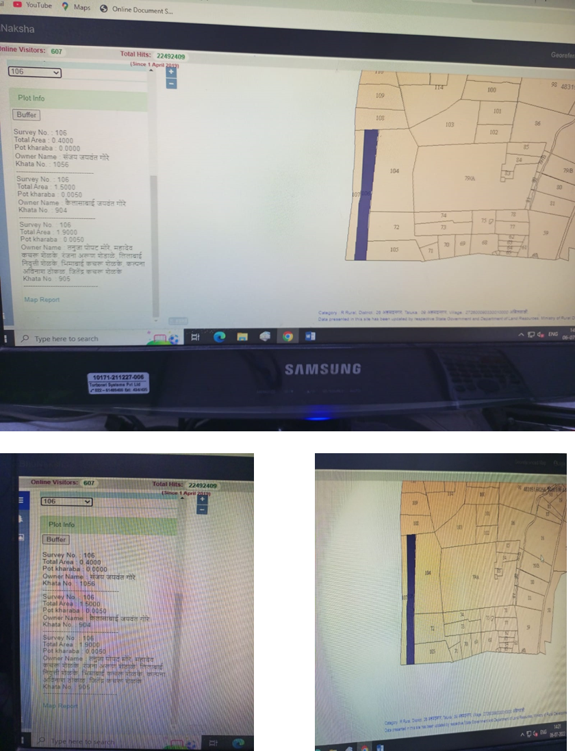
Figure 1 pictures are from mahabhumi.gov.in, In these pictures land boundaries can be seen, in which survey no is on the east, west, north, and south can be identified by this, with these other details such as owner’s name, Pot kharaba, Khata no, total area and survey number are shown on the website when searching for any survey number.
Every local body (Government organization)/ Gram panchayat has its website for checking of ownership of land (historical data).
At the time of valuation, trees might come on the boundaries of land, or a lot of trees are there which can create a problem while surveying land, with this identification of roads on boundaries of the land is difficult.
Google maps can clear this problem, by google maps, we can see the top view of the land, boundaries of land and roads which are on the corners of the land.
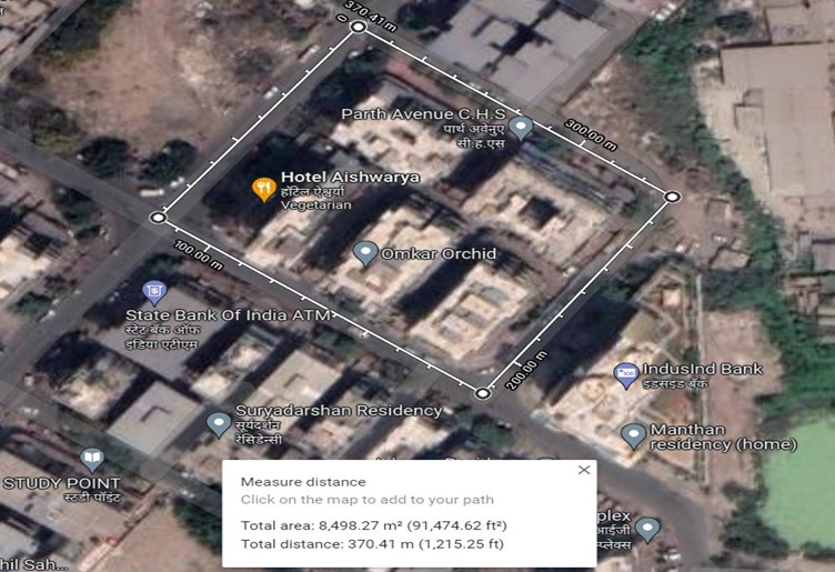 Figure 2 picture is from google maps, It’s a satellite view. For viewing such images, first, you must input the location of land, after that right click on selected land, then choose the last option from the drop-down which is measure distance, after clicking on that google maps it will show the total area in m2 and in sq. ft, for getting the real-time image of land, select satellite view.
Landowners by manipulating documents can fraud a bank/valuer. They can show the manipulated documents to the bank and if the bank doesn’t cross-check by using government websites and by doing physical visits, they could be in severe trouble.
This document will provide clear instructions on how to be safe in land parcel transactions and what steps to follow for the banker or valuer when identifying a property in practice. Land parcel transactions have historically been very difficult jobs where many frauds and manipulations have started to occur.
Bibliography
Government website. (2022, July 3). Retrieved from mahabhumi: https://mahabhumi.gov.in/mahabhumilink
https://www.google.com/maps/@19.0233149,73.0759443,15z. (2022, July 3). Retrieved from https://www.google.com/maps/@19.0233149,73.0759443,15z: https://www.google.com/maps
Author- Mr. Prashant A. Gawali (B.E in Civil engineering), Pursuing MBA in Construction Project Management
Under guidance of Mr. Siddharth S. thite, Director at Thite Valuers and Engineers Pvt. Ltd, Registered Valuer, MRICS, MS (Civil, USA)
Applications 2024 Open Now

Popular Searches:
Programmes - Construction Management Course | Masters in Construction Management in India | Construction Management Course in India | | MBA in Infrastructure Management | MBA in Real Estate Management | MBA in Real Estate Management | Real Estate Courses in India | Course Real Estate Management | MBA in Real Estate | Quantity Surveying | Quantity Surveying Courses | Quantity Surveying in Civil Engineering | Quantity Surveyor Course MBA Courses | BBA Real Estate
Admission - MBA Admission | BBA Admission | MBA Admission Process | BBA Admission Process | MBA Admission 2024 | BBA Admission 2024
Others - Courses for Civil Engineering | Project Management Salary | Construction Project Manager | Business in Real Estate | MBA Courses | Business in Real Estate |


